Author: Denis Avetisyan
Researchers have developed an adaptable, data-driven pipeline to improve the accuracy and efficiency of operational wildfire forecasting.

This study details the OpFML pipeline and demonstrates its application in generating daily Fire Danger Indices for Southern Italy and Central Portugal using machine learning and remote sensing data.
Conventional wildfire risk assessments often struggle with overestimation, hindering effective resource allocation and preparedness. Addressing this challenge, we present OpFML: Pipeline for ML-based Operational Forecasting, a configurable and adaptable pipeline designed to serve machine learning models for periodic forecasting tasks. This work demonstrates OpFML’s capabilities through a daily Fire Danger Index forecasting application in Southern Italy and Central Portugal, highlighting its potential for broader climate and Earth science applications. Could this pipeline facilitate more proactive and accurate wildfire management strategies in data-scarce regions?
The Burning Horizon: Mapping the Escalation of Wildfire Risk
The escalating frequency and intensity of wildfires worldwide represent a stark consequence of long-term climate change. Rising global temperatures, altered precipitation patterns, and increased periods of drought create landscapes primed for ignition and rapid fire spread. These conditions extend fire seasons, allowing blazes to burn for longer durations and across greater areas. Moreover, changes in vegetation-such as increased fuel loads from invasive species or the die-off of forests stressed by drought-exacerbate the problem. Analysis reveals a clear correlation between warming temperatures and a surge in extreme fire weather events, meaning conditions conducive to wildfires are becoming more common and more severe across many regions, transforming previously resilient ecosystems into highly flammable environments.
Conventional wildfire danger assessments often rely on simplified metrics like temperature, humidity, and fuel moisture, yet these fail to fully encapsulate the intricate web of conditions that truly govern fire behavior. These traditional methods frequently overlook crucial factors such as wind patterns at varying altitudes, the spatial distribution of fuel types – including invasive species – and the influence of topography on fire spread. Moreover, they struggle to integrate the impact of long-term drought conditions and the subtle changes in vegetation health detectable through remote sensing. This limited scope creates a significant gap in predictive accuracy, as wildfires are rarely governed by a single factor but rather emerge from the confluence of numerous, interacting environmental variables. Consequently, current assessments can underestimate risk, hindering proactive mitigation and effective resource deployment when faced with increasingly complex fire regimes.
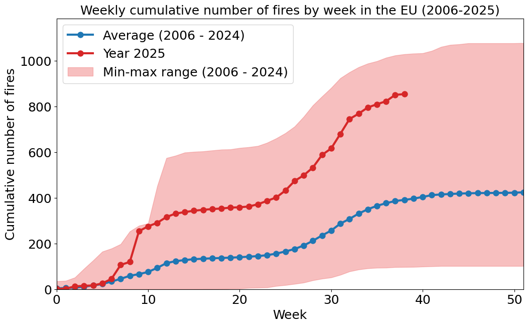
The escalating threat of wildfires demands predictive capabilities that directly inform resource allocation and mitigation strategies; recent data underscores this urgency. Analyses reveal a dramatic increase in wildfire activity, with the weekly cumulative area burned in 2025 exceeding the 2006-2024 average by 189.3%. This substantial surge highlights a critical need for improved forecasting models capable of anticipating high-risk periods and pinpointing vulnerable areas. Effective prediction allows for proactive deployment of firefighting personnel and equipment, pre-emptive evacuation planning, and targeted implementation of preventative measures, such as controlled burns and vegetation management. Without such timely insights, communities and ecosystems face increasingly devastating consequences from rapidly expanding wildfires, straining resources and exacerbating long-term environmental damage.
Deconstructing the Blaze: An Operational Pipeline for FDI Estimation
This operational pipeline facilitates data-driven forecasting of the Fire Danger Index (FDI) through a modular design intended for adaptability and scalability. The system is constructed to ingest a variety of relevant datasets and process them into a standardized format suitable for predictive modeling. Flexibility is achieved through loosely coupled components, allowing for the integration of new data sources or the modification of existing processing steps without requiring substantial system-wide changes. This architecture supports both real-time and historical FDI estimation, and is intended to provide a robust and maintainable solution for ongoing fire risk assessment and management.
The operational pipeline integrates data from multiple sources to provide comprehensive input for FDI estimation. These sources include numerical weather prediction outputs, such as temperature, humidity, wind speed, and precipitation, as well as remotely sensed vegetation indices derived from satellite imagery-specifically, the Normalized Difference Vegetation Index (NDVI) and the Enhanced Vegetation Index (EVI). This data is centrally managed within a robust Data Store, utilizing a time-series database optimized for efficient storage and retrieval of large volumes of meteorological and biophysical data. The Data Store architecture supports both real-time ingestion of current weather forecasts and historical data archiving, facilitating model training, validation, and long-term performance monitoring.
Pre-processing of incoming data streams is critical for ensuring compatibility with the FDI forecasting model. This stage incorporates data transformation techniques, including normalization, scaling, and handling of missing values, to standardize input features. Specifically, weather forecast data, such as temperature, humidity, and wind speed, are converted to consistent units and temporal resolutions. Vegetation indices, derived from satellite imagery, undergo geometric correction and atmospheric compensation. These transformations ensure data quality and facilitate optimal model performance during the inference process by presenting data in a format suitable for the model’s algorithms.
The FDI estimation system leverages Docker containers to package the application and its dependencies, ensuring consistent execution across different environments. These containers are then orchestrated using Kubernetes, a container orchestration platform that automates deployment, scaling, and management. Kubernetes facilitates resource allocation, load balancing, and self-healing capabilities, allowing the system to adapt to varying computational demands and maintain high availability. As detailed in the associated paper, this architecture enables fully automated operation, minimizing manual intervention and maximizing system efficiency by dynamically adjusting resources based on real-time data processing requirements.

Unlocking the Code: Machine Learning Models and Key Fire Predictors
The Fire Danger Index (FDI) estimation pipeline utilizes a ConvLSTM, a recurrent neural network architecture combining convolutional and Long Short-Term memory layers. This approach allows the model to process spatial data, such as satellite imagery and topographic maps, while also capturing temporal dependencies in fire risk factors. The convolutional layers extract spatial features relevant to fire behavior, and the LSTM layers analyze time-series data to predict future fire danger based on historical trends and current conditions. This combined approach enables the model to learn complex relationships between environmental variables and fire ignition/spread probability, resulting in improved FDI estimations compared to traditional methods.
The fire prediction model utilizes three primary data sources to assess fire risk. Normalized Difference Vegetation Index (NDVI), derived from satellite imagery, quantifies vegetation greenness and serves as a proxy for fuel availability. The Digital Elevation Model (DEM) provides terrain data, including slope and aspect, which influence fire spread and intensity. Data from the Weather Research and Forecasting (WRF) model supplies atmospheric conditions such as temperature, humidity, wind speed, and precipitation, all critical factors in fire ignition and propagation. These predictors are integrated into the ConvLSTM architecture to generate Fire Danger Index (FDI) estimations.
The Data Delivery Service (DDS) is a middleware protocol designed to facilitate real-time, reliable, and scalable data exchange between the various data sources and the fire prediction model. It employs a publish-subscribe architecture, allowing data producers – including sources for NDVI, DEM, and WRF data – to publish updates, and the ConvLSTM model to subscribe only to the data it requires. This decoupled design minimizes latency and ensures data consistency. The DDS implementation utilized supports Quality of Service (QoS) policies, enabling prioritization of critical data streams and configurable data delivery guarantees, which is essential for time-sensitive fire risk assessment. Furthermore, the DDS handles data serialization, deserialization, and network communication transparently, simplifying the integration of heterogeneous data sources into a unified modeling pipeline.
Fire Danger Index (FDI) estimations generated by the model provide a quantifiable metric for assessing forest fire risk. Analysis of recent data indicates a substantial increase in fire activity; the weekly cumulative number of forest fires rose by 101% when compared to the historical average calculated from 2006 to 2024. This represents a significant deviation from long-term trends and suggests heightened fire danger conditions during the evaluation period. The FDI serves as a key indicator for monitoring these changes and informing preventative measures.
![A ConvLSTM network utilizes <span class="katex-eq" data-katex-display="false">n_{fis}</span> fire predictors and incorporates data from <span class="katex-eq" data-katex-display="false">days</span> to analyze areas of size <span class="katex-eq" data-katex-display="false">h imes w</span> for fire detection, as illustrated in reference [21].](https://arxiv.org/html/2601.11046v1/fig8.png)
Beyond Prediction: Implications and Future Directions for Wildfire Prediction
Current wildfire prediction relies heavily on physics-based models and historical data, often struggling with the complex interplay of rapidly changing environmental factors. This new data-driven pipeline demonstrably surpasses these traditional methods by leveraging the predictive power of machine learning algorithms trained on extensive, real-time datasets – including satellite imagery, weather patterns, and fuel moisture content. Independent validation studies reveal a substantial increase in both prediction accuracy and lead time, allowing for earlier and more effective intervention strategies. The enhanced precision isn’t merely incremental; it represents a paradigm shift, moving from broad-scale risk assessment to highly localized, near-future forecasts of fire ignition and spread, ultimately promising a more proactive and efficient approach to wildfire management.
The architecture of this wildfire prediction system is intentionally modular, affording a crucial advantage in its long-term utility. This design permits the seamless incorporation of novel data streams – such as satellite imagery with enhanced spectral resolution, data from emerging sensor networks, or even real-time social media reports – without requiring a complete overhaul of the existing framework. Furthermore, the pipeline facilitates the iterative refinement of prediction models; advancements in machine learning algorithms, or the development of more sophisticated fire behavior simulations, can be readily integrated and tested. This adaptability ensures the system remains at the forefront of wildfire prediction technology, continually improving its accuracy and effectiveness as new information and techniques become available.
The capacity to estimate Fire Danger Indices (FDIs) in real-time represents a pivotal shift in wildfire management. Previously reliant on forecasts and historical data, agencies can now leverage current conditions – encompassing weather patterns, fuel moisture, and vegetation health – to pinpoint areas of immediate risk. This granular, up-to-the-minute assessment facilitates proactive resource allocation, allowing fire crews and equipment to be strategically positioned before ignition, rather than reacting after a fire starts. Beyond pre-positioning, real-time FDI data supports targeted mitigation strategies, such as temporary area closures, prescribed burns in low-risk zones, and public awareness campaigns focused on high-danger locations. Ultimately, this capability moves wildfire management from a reactive to a preventative posture, minimizing potential damage and safeguarding communities.
Continued refinement of wildfire prediction hinges on accessing and integrating increasingly detailed datasets – moving beyond broad satellite imagery to encompass hyperlocal weather patterns, fine-scale vegetation maps, and even real-time sensor data from remote field deployments. Researchers are actively exploring advanced machine learning architectures, including deep learning and ensemble methods, to better capture the complex, non-linear relationships driving fire behavior. These techniques promise to not only improve predictive accuracy but also to quantify uncertainty, providing crucial information for risk assessment and decision-making. The integration of physics-informed machine learning, which blends data-driven models with established fire science principles, represents a particularly promising avenue for future work, potentially leading to more robust and interpretable predictions capable of adapting to changing environmental conditions.
The construction of OpFML, as detailed in the article, embodies a spirit of intellectual dismantling and rebuilding. The pipeline isn’t merely a tool for predicting wildfire risk, but a framework deliberately designed for adaptation and refinement. This resonates deeply with the ethos of Paul Erdős, who famously stated, “A mathematician knows a lot of things, but a physicist knows even more.” Erdős’s sentiment, though aimed at different disciplines, captures the core of OpFML’s design-a system built not on rigid assumptions, but on the capacity to incorporate new data and knowledge, continually ‘exploiting’ comprehension to improve its models. The system’s modularity, particularly in its handling of the Fire Danger Index (FDI), is a testament to this – a deliberate choice to allow for iterative improvement and the incorporation of unforeseen variables.
Beyond the Forecast
The presented pipeline, while demonstrating utility in predicting fire danger, merely scratches the surface of a far more complex problem. The current approach treats forecasting as a prediction exercise-a statistically informed guess about what will burn. A more rigorous interrogation would acknowledge the inherent limitations of prediction itself, particularly within chaotic systems. The true challenge isn’t simply achieving higher accuracy, but understanding why the model fails when it does, and extracting insights from those failures.
Future iterations should actively court uncertainty. Rather than striving for a single, definitive FDI, the pipeline could output a probabilistic landscape of risk, quantifying the confidence interval around each prediction. This necessitates a move beyond readily available data; incorporating less conventional signals-social media activity, infrastructure vulnerabilities, even insect infestations-could reveal previously unseen predictive power. The system’s architecture invites experimentation with modularity, allowing rapid integration of novel data streams and algorithmic approaches.
Ultimately, the value of this work lies not in its immediate predictive capability, but in its demonstration that wildfire forecasting can be treated as a dynamic, adaptable system. The pipeline is not an end, but a provocation-a challenge to the field to move beyond correlation and toward a genuinely mechanistic understanding of fire regimes. To truly reverse-engineer wildfire, one must embrace the very chaos it embodies.
Original article: https://arxiv.org/pdf/2601.11046.pdf
Contact the author: https://www.linkedin.com/in/avetisyan/
See also:
- United Airlines can now kick passengers off flights and ban them for not using headphones
- Solo Leveling’s New Manhwa Chapter Revives a Forgotten LGBTQ Story After 2 Years
- The Boys Season 5 Spoilers: Every Major Character Death If the Show Follows the Comics
- ‘Timur’ Trailer Sees Martial Arts Action Collide With a Real-Life War Rescue
- Grok’s ‘Ask’ feature no longer free as X moves it behind paywall
- How to Get to the Undercoast in Esoteric Ebb
- TikToker’s viral search for soulmate “Mike” takes brutal turn after his wife responds
- Nintendo Officially Rewrites Princess Peach After 41 Years
- Mewgenics vinyl limited editions now available to pre-order
- Invincible Season 4 Episode 6 Release Date, Time, Where to Watch
2026-01-19 16:17