Author: Denis Avetisyan
A new reinforcement learning framework helps urban planners proactively design resilient transportation systems capable of weathering long-term climate change and minimizing disruption from flooding.
This study demonstrates a novel approach to long-term climate adaptation planning, using reinforcement learning to optimize transport adaptation pathways under direct and indirect flood impacts in Copenhagen.
Long-term infrastructure planning faces inherent challenges when balancing proactive adaptation with deep uncertainty about future climate risks. This is addressed in ‘Learning long term climate-resilient transport adaptation pathways under direct and indirect flood impacts using reinforcement learning’, which introduces a novel decision-support framework coupling integrated assessment modeling with reinforcement learning to optimize multi-decade investment pathways. The approach learns adaptive strategies that minimize transport disruptions and societal costs from pluvial flooding, demonstrated through a case study in Copenhagen, yielding improved robustness compared to conventional planning approaches. Could this framework be generalized to address a broader range of climate hazards and accelerate climate-resilient infrastructure development in cities worldwide?
The Inevitable Uncertainty of Urban Flooding
The escalating impacts of climate change are manifesting in a discernible rise in both the frequency and intensity of extreme weather events, with pluvial flooding – runoff exceeding drainage capacity – posing an increasingly critical threat to urban infrastructure. This form of flooding, distinct from riverine or coastal events, is particularly acute in cities due to extensive impermeable surfaces and aging drainage systems. Recent studies demonstrate a clear correlation between increased atmospheric moisture, driven by warmer temperatures, and more frequent, intense rainfall events. Consequently, critical infrastructure – including transportation networks, power grids, and communication systems – face heightened risks of disruption and damage. The economic consequences extend beyond immediate repair costs, encompassing business interruption, reduced property values, and long-term societal impacts, necessitating proactive adaptation strategies to bolster urban resilience.
Conventional long-term climate adaptation planning faces escalating challenges due to a phenomenon known as deep uncertainty – a situation where future conditions are not merely unknown, but fundamentally unpredictable. Historical data, the cornerstone of traditional forecasting, becomes less reliable as climate change introduces novel conditions and cascading effects. This makes it increasingly difficult to accurately project the frequency and severity of extreme events, or to confidently assess the performance of proposed interventions over decades. For instance, infrastructure designed for a specific rainfall intensity may quickly become inadequate as precipitation patterns shift, rendering long-range projections obsolete. The inherent complexities of climate systems, coupled with socioeconomic factors and policy choices, contribute to this deep uncertainty, demanding a shift away from rigid, prescriptive plans towards more flexible and adaptive strategies.
Recognizing the limitations of static, long-term planning in the face of climate change, researchers are advocating for adaptive approaches to urban resilience. These strategies move beyond predicting a single future scenario and instead embrace a portfolio of plausible outcomes, acknowledging that the precise nature of future climate risks remains unknown. Dynamic adaptation involves continuous monitoring of conditions, iterative adjustments to interventions, and flexible infrastructure designs capable of performing well across a range of possibilities. This necessitates a shift from prescriptive plans to learning-based management, where policies are treated as hypotheses to be tested and refined as new information emerges, ultimately fostering a more robust and responsive urban environment capable of weathering unforeseen challenges.
A Holistic Model for Climate Risk Assessment
The developed Integrated Assessment Model (IAM) provides a comprehensive climate risk assessment by linking four key components. Climate scenarios, derived from sources such as the Danish Meteorological Institute, inform hazard modeling which simulates potential events like flooding. This hazard data is then inputted into infrastructure simulations, allowing for the analysis of system performance under stress. Finally, impact quantification assesses the consequences of these events, providing a holistic view of climate-related risks and enabling data-driven decision-making. The IAM’s integrated nature allows for the propagation of uncertainty from climate projections through to quantified impacts, offering a more robust risk evaluation than traditional, siloed approaches.
The Integrated Assessment Model (IAM) simulates flood events in Copenhagen by integrating spatially detailed geographic data with projected rainfall patterns. OpenStreetMap data provides the foundational representation of the city’s topography, building footprints, and road networks, defining the physical environment subject to flooding. This data is combined with rainfall projections sourced from the Danish Meteorological Institute, which provide forecasts of precipitation intensity and duration. These inputs drive the hydrodynamic modeling component, enabling the simulation of water flow and inundation across the urban landscape. The resolution of both the OpenStreetMap data and the rainfall projections are critical to accurately representing localized flooding phenomena and their impact on infrastructure.
The model employs SCALGO Live for high-resolution, event-based flood simulations, generating detailed flood extents and water depths for specific rainfall scenarios. These outputs are then integrated with Travel Demand Modeling techniques to assess the impact of flooding on urban transport networks. This integration allows for the quantification of disruptions to transportation infrastructure, including road closures and accessibility changes, based on simulated flood conditions and predicted travel patterns. The resulting data provides insights into the vulnerability of the transport network and potential cascading effects of flood events.
Reinforcement Learning: An Adaptive Control Strategy
Reinforcement Learning (RL) is integrated into the Integrated Assessment Model (IAM) to develop adaptation policies designed to reduce flood risk. This approach enables the system to learn through trial and error, iteratively improving its strategies for managing flood defenses and infrastructure adjustments. The RL component dynamically responds to simulated flood events and changing climate conditions within the IAM, allowing it to identify optimal sequences of actions-such as reinforcing levees, improving drainage systems, or implementing early warning systems-to minimize potential damage and associated costs. This learning process is data-driven, adapting policies based on the observed outcomes of previous decisions within the model’s simulated environment.
The system utilizes Reinforcement Learning (RL) to determine adaptive strategies under conditions of uncertainty by framing the problem as a Markov Decision Process (MDP). An MDP defines states representing the condition of the urban infrastructure, actions representing potential adaptation interventions, and rewards quantifying the cost-effectiveness of those interventions. Proximal Policy Optimization (PPO) is employed as the RL algorithm due to its stability and efficiency in learning optimal policies within complex state spaces. PPO iteratively refines the adaptation policy by maximizing cumulative rewards while ensuring that policy updates remain within a trust region to prevent drastic performance drops, enabling robust decision-making in the face of unpredictable flood events.
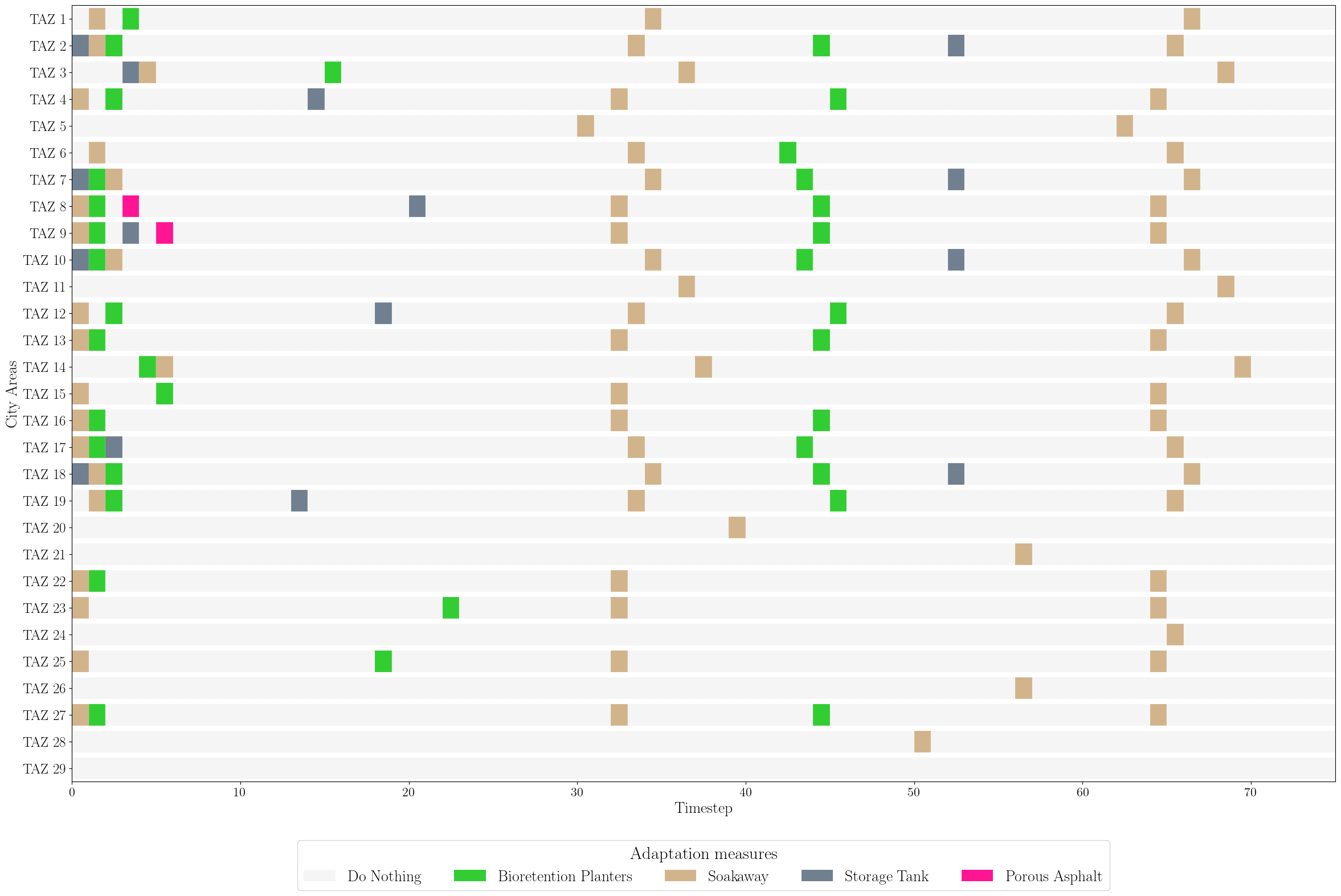
The urban environment is modeled as a graph, where nodes represent critical infrastructure components – such as buildings, drainage systems, and transportation networks – and edges define their spatial connectivity. This graph structure is then processed by a Graph Neural Network (GNN), enabling the Reinforcement Learning (RL) agent to understand the interdependencies within the city’s infrastructure. The GNN learns node embeddings that capture both individual component attributes and relational information derived from the graph’s topology. This allows the RL agent to move beyond isolated assessments and consider the cascading effects of adaptation strategies across the interconnected urban system, ultimately informing more holistic and effective flood mitigation policies.
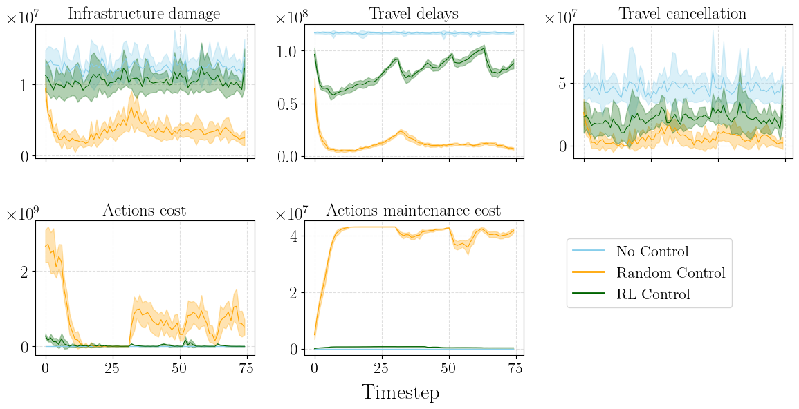
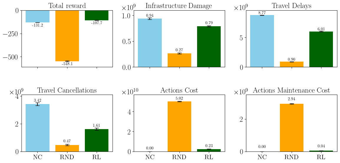
The implemented Reinforcement Learning policy demonstrated a 22% reduction in cumulative total cost when applied to long-term climate adaptation planning for Copenhagen’s inner city, as compared to a ‘No Control’ baseline scenario. This cost reduction was calculated by modeling various adaptation strategies and their associated expenses – including infrastructure upgrades, maintenance, and potential damage costs – over a defined planning horizon. The ‘No Control’ baseline represented a scenario where no proactive adaptation measures were implemented, resulting in higher cumulative costs due to increased flood damage. This quantitative result validates the efficacy of the RL approach in optimizing adaptation strategies and reducing the financial burden of climate change impacts within the specified urban environment.
Translating Risk into Economic Reality
An Integrated Assessment Model (IAM) provides a crucial ability to translate the complex risks of pluvial flooding – rainfall-generated urban floods – into measurable economic and social consequences for Copenhagen’s transportation systems. This isn’t simply about calculating damage to roads and rails; the model quantifies the cascading effects of disruptions, factoring in lost productivity, missed appointments, and the broader impact on daily life. By assigning concrete values to these impacts, the IAM moves beyond abstract risk assessments, allowing city planners to understand the true cost of inaction and to prioritize investments in adaptation strategies that offer the greatest return in terms of reduced economic loss and improved societal resilience. The result is a powerful tool for informed decision-making, enabling a proactive approach to managing the increasing threat of urban flooding.
The economic repercussions of pluvial flooding extend beyond physical damage to infrastructure; disruptions to transportation networks impose significant costs through travel delays. By integrating the concept of the Value of Time – a metric representing the economic cost of lost productivity and convenience due to delays – a more comprehensive assessment of flood impacts becomes possible. This allows for the quantification of the financial burden imposed by even short disruptions to commutes and freight transport. Consequently, adaptation investments can be strategically prioritized, focusing on projects that yield the greatest reduction in both infrastructure damage and travel delays, ultimately maximizing the return on investment and bolstering the resilience of urban transport systems.
The developed Integrated Assessment Model (IAM) transcends a simple cost-benefit analysis; it functions as a dynamic platform for long-term climate adaptation planning. By integrating detailed data on Copenhagen’s transport network, predicted pluvial flooding scenarios, and the economic value of time saved, the framework allows city planners to simulate the impacts of various adaptation strategies before implementation. This proactive capability extends beyond immediate cost reduction, facilitating iterative adjustments to investment priorities based on evolving climate projections and network performance. The model’s flexibility ensures it remains relevant despite uncertainties in future climate patterns, offering a resilient tool for safeguarding critical infrastructure and minimizing disruptions to urban mobility – a crucial component of a city’s ability to thrive in a changing climate.
Analysis reveals a reinforcement learning (RL) policy for Copenhagen’s pluvial flood management significantly outperforms a random control approach, achieving a remarkable 408% reduction in cumulative total cost. This improvement isn’t solely financial; the RL policy consistently minimizes infrastructure damage, diminishes travel delays, and reduces transport cancellations, all while maintaining lower and more predictable adaptation expenditures. The framework demonstrates that proactive, learning-based strategies are not only more effective at mitigating flood impacts but also offer a pathway to cost-optimized, resilient infrastructure planning, suggesting a substantial return on investment for climate adaptation measures.
The pursuit of optimal adaptation pathways, as detailed in the study concerning Copenhagen’s transport resilience, echoes a fundamental tenet of computational rigor. The framework’s reliance on reinforcement learning to navigate complex flood risks and minimize disruptions aligns with the principle that solutions must be demonstrably correct, not merely appear functional. As John McCarthy aptly stated, “The best way to predict the future is to invent it.” This sentiment underscores the proactive nature of the research, which doesn’t passively anticipate climate change impacts but actively constructs resilient strategies through algorithmic precision. The study’s focus on sequential decision-making, crucial for long-term planning, exemplifies the mathematical purity sought in effective problem-solving.
Beyond Pragmatism: Charting a Course for Robust Adaptation
The presented framework, while demonstrably effective within the Copenhagen context, skirts the fundamental question of provability. Success measured by minimizing disruption on simulated networks, however complex, remains an empirical observation-not a logical necessity. A truly elegant solution would not merely perform well, but would be demonstrably optimal under a defined set of axioms relating climate impact, infrastructural resilience, and acceptable risk. The current reliance on reward functions, however cleverly designed, introduces a degree of arbitrariness that feels… unsatisfying. One must ask: optimal with respect to what?
Future work must move beyond purely data-driven approaches. Integrating formal methods – perhaps theorem proving or model checking – to verify the emergent adaptation strategies could offer a level of assurance currently absent. Furthermore, extending the model to explicitly account for the cost of adaptation itself-not just disruption-introduces a necessary economic dimension. The framework presently optimizes for mitigation of consequences; a complete solution must optimize for the least costly path to resilience, a problem intrinsically suited to mathematical optimization.
Ultimately, the challenge lies in transforming climate adaptation from an exercise in applied statistics into a branch of applied logic. Only then can one claim, with genuine confidence, that the chosen path is not simply ‘good enough’, but demonstrably, mathematically, correct. The pursuit of such rigor may seem ambitious, but it is the only path to truly sustainable and reliable long-term planning.
Original article: https://arxiv.org/pdf/2601.18586.pdf
Contact the author: https://www.linkedin.com/in/avetisyan/
See also:
- United Airlines can now kick passengers off flights and ban them for not using headphones
- All Itzaland Animal Locations in Infinity Nikki
- Katanire’s Yae Miko Cosplay: Genshin Impact Masterpiece
- How to Complete Bloom of Tranquility Challenge in Infinity Nikki
- How to Get to the Undercoast in Esoteric Ebb
- A Dark Scream Theory Rewrites the Only Movie to Break the 2-Killer Rule
- All Golden Ball Locations in Yakuza Kiwami 3 & Dark Ties
- Gold Rate Forecast
- 6 Ways Invincible Season 4’s Hell Episode Rewrites The Comics
- BloxStrike codes (March 2026)
2026-01-28 00:44